Richmond resident Doug Allen has been biking in the city for about two decades. His bike was his main means of transportation in college when he couldn’t afford a car. He decided to keep using his bike after he graduated.
“I did have a car for a couple of years. It was nice to have, but I had already figured out how to get around on a bike. That’s the hard part,” Allen said. “I was glad to eventually get rid of it because of the inconveniences that come with a car between parking and gas.”

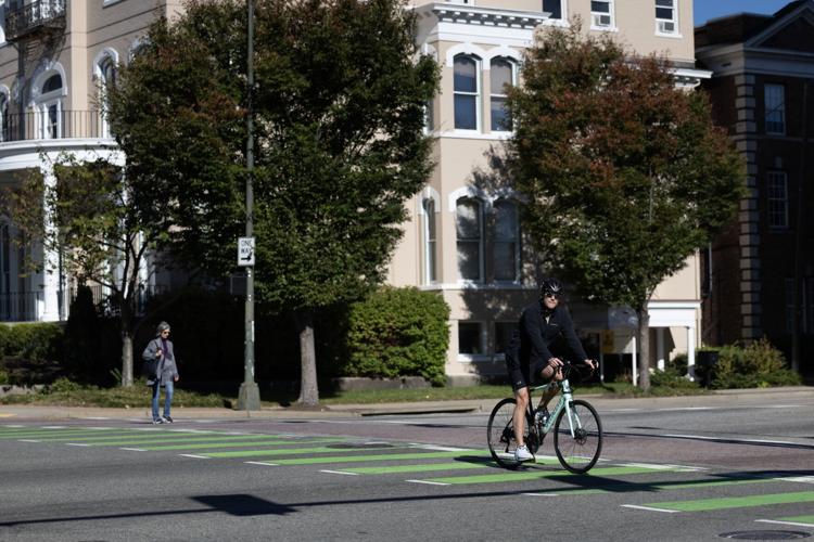
Scott Resetar crosses Belvidere Street on Franklin Street on Friday during his afternoon commute from downtown to his house in the Fan. Resetar crosses this intersection twice a day and was once hit by a car turning right on red. He was not hurt, but the back tire of his bicycle was bent. “This is probably the most dangerous intersection,” Resetar said.
That choice comes with a tradeoff. Biking in the Richmond area often means riding on tight or busy roads with cars whizzing past, sometimes at speeds upward of 50 mph.
Local governments across central Virginia are actively planning — and more crucially, investing in — a network of trails to keep bikers safe. That network, however, is still in its infancy, and it could take decades for ubiquitous, safe and efficient bike travel to become a reality.
People are also reading…
The lack of biking infrastructure can be seen in the deaths that have occurred on roads since 2019 across Richmond and Henrico and Chesterfield counties.
14 cyclists killed in 5 years
According to the data from the Virginia Department of Transportation, 14 cyclists have been killed in that time. All of those deaths happened at intersections on busy streets, along fast-moving roads without separated lanes, or on narrow roads without any shoulder, forcing bikers into lanes built for cars.
There were nearly 450 total accidents involving bikers, although experts say it’s likely those numbers are underreported.
PlanRVA is the regional growth coordinator for nine central Virginia localities, including Richmond, Henrico and Chesterfield. It’s BikePedRVA 2045 notes that pedestrian deaths in general rose 45% between 2019 and 2022.
That increase was attributed to more people driving large vehicles like trucks and SUVs, road designs leading to higher vehicle speeds and federal safety measures being targeted at drivers and not people outside of a vehicle.
Allen is a seasoned rider who is used to cycling next to traffic, finding slower roads or riding among cars at traffic lights when necessary. He says that the city has come a long way in the past 10 years to bring infrastructure like bike lanes to certain areas, but that it still has a long way to go.
“Parts of Richmond are very good for getting around on a bike, but it’s very much concentrated in a few areas,” Allen said.
Neighborhoods are dense enough where you can easily find side streets with 25 mph speed limits that slow cars enough to notice riders or give them space.
Bike lanes have also popped up on some speedier roads such as West Franklin Street downtown. Richmond is starting construction on three more separated bike lanes downtown before the end of October to expand the network in Richmond’s commuter center.
Allen says the issue is connecting from one of these areas to another. Those Franklin Street bike lanes, for example, simply end when they hit North Belvidere. Bikers have to cycle toward oncoming traffic when crossing the street.
“Usually, the shortest part of a route feels like the longest because it’s the most stressful and the most dangerous place, which is usually an intersection or a bridge,” Allen said.


Much of region was designed for cars
Allen is hardly alone in living a car-less lifestyle. Among workers 16 years and older in Richmond, Henrico and Chesterfield, 17,600 do not have a car, according to the U.S. Census Bureau.
Cycling is one of their only options for travel, along with walking and public transit.
Much of the Richmond area, like many cities across the nation, was designed with the automobile in mind. The city itself still has remnants of car-less travel in the form of sidewalks and the former trolley lines followed by the current Pulse bus route, but that’s less true the farther out you get from the city center.
Growth in the counties largely came after the automobile, and they have relatively little infrastructure for biking.
Nationally, the number of people cycling to work increased 37% from 2019 through 2022, according to a report by transportation data and analytics firm StreetLight.
The Richmond metropolitan region saw the biggest increase among top metro areas in the country in 2022 with a 19% rise over the previous year, according to that report. It had the fifth-highest growth rate nationwide between 2020 and 2022. StreetLight noted that biking may be gaining momentum in the region.
Despite that growth, the region is still far behind areas with more developed trail systems.
The Washington and Old Dominion Railroad Regional Park in Northern Virginia — known as the W&OD trail — is a sprawling network that connects densely populated areas of Arlington, Fairfax County and Ashburn together with a 45-mile route along a former railroad.
Phil Riggan, a transportation planner with PlanRVA, said the W&OD is a great example of an effective and efficient transportation network that is easy for people of all skill levels. It also has more robust partitions and bridges to keep bikers and walkers separated from traffic.
That trail celebrated its 50th anniversary this year.
Central Virginia is currently building the spine of a trail network that could eventually be as complete as the W&OD trail. The roughly $400 million Fall Line Trail from Ashland to Petersburg broke ground last year.
Once completed, that trail is planned to spawn several spurs leading from its centralized route across those counties and the city of Richmond into neighborhoods, business centers and schools.
“We’re talking 30 to 40 years for some of that,” Riggan said. “We’re kind of playing catch-up to get to what (Northern Virginia) has.”
Relatively few bike paths exist currently outside of several disconnected stretches.

Two cyclists wait to cross Belvidere Street on Franklin Street on Friday. The lack of biking infrastructure can be seen in the deaths that have occurred on roads since 2019 across Richmond and Henrico and Chesterfield counties.
What does safe infrastructure look like?
Trey Dunnaville is president for the local group Richmond Area Bicycling Association. His travels take him around the region from Richmond to Henrico and Chesterfield. He says he is always thinking about his safety and planning routes based on the time of day, how many lanes a road has, how fast traffic moves and whether other bikers will be with him so he will be more visible to drivers.
He’s never been in an accident, but he’s ridden with people who have been in both major and minor accidents.
He says there is no amount of safety gear that can make up for a lack of biking infrastructure.
“I’ve been out on roads and many cars are great, they’ll give you a ton of space. Other times, cars will pass within feet of you even if there is no car on the other side of the road,” Dunnaville said.
Dunnaville said cars have turned right in front of his path when he’s biking even when there has been a painted bike lane.
“The idea of wearing bright colored clothing or headlamps still is not enough to change whether or not some drivers will behave appropriately or not endanger you. We can do all the things we want and drivers will still do things that put you in danger.”
BikePedRVA 2045 calls for safer road designs that narrow lanes to slow cars and reduced overall speed limits. It also calls for high-visibility crosswalks, crossing signals with push buttons and crosswalks for long intersections. It also says turn lanes can cause cars to travel faster, and right-angle turns are preferred.
A fully developed biking network will likely follow different routes than motorists are used to traveling. A safe biking pathway might forgo travel on such busy thoroughfares as Broad Street or Midlothian Turnpike in favor of adjacent streets with slower speeds and fewer cars.
The goal is creating an efficient trail network that separates bikes from cars without taking cyclists too far out of their way where they will expend precious energy and time.
The BikePedRVA 2045 plan lays out goals for a regional network with standards that include 10-foot-wide paths.
“You’re planning routes for an 8-year-old. How would a child bike along this path and be safe? Or how would somebody who is nervous, but wants to ride, feel comfortable?” Riggan said.
Crossing highways and busy roads are the most difficult problems to solve. Henrico is building a walking and biking bridge across Interstate 95 at the Magellan Parkway to unite the east and the west. But those types of crossings can be somewhat limited in number, Riggan said.
Intersections could be retrofitted for better crosswalks, painting and signals to make cars aware of bikers. Riggan said that after a network is built and established, those crossings can become more robust and separated from traffic over time.

A cyclist and a pedestrian cross Belvidere Street on Franklin Street in Richmond on Friday. Local governments across central Virginia are actively planning and investing in a network of trails to protect bikers. But it could take decades for ubiquitous, safe and efficient bike travel to become a reality.
Building a network for all
Doug Allen rides with Breakaway RVA, a group that is largely targeted at getting beginners out on bikes and taking them to various places of historical or cultural interest. While he says the city has made great strides in the past decade, South Side Richmond is still the worst in terms of infrastructure.
Riggan says PlanRVA wants to coordinate a network that also prioritizes South Side, which has a higher concentration of low-income residents who do not have cars.
He said the Fall Line Trail, as the region’s spine, can hopefully bring upgrades to the historically disinvested Route 1 corridor.
He also says it’s possible that reliable biking infrastructure could impact traffic congestion levels in the long run by getting an amount of cars off the street.
“Folks who have been waiting for curb, gutter and sidewalks for 50 years,” Riggan said, “may finally at least get some safer connectivity along a busy and dangerous regional roadway.”


5 common causes of fatal pedestrian accidents—and how to protect yourself
5 common causes of fatal pedestrian accidents—and how to protect yourself

Everyone knows that driving comes with its hazards. But going out for a walk can also be an intrinsically risky proposition. Impatient walkers, intoxicated drivers (and pedestrians), and stopping in crosswalks are mistakes that drivers and walkers alike can make that lead to catastrophic consequences.
The Patel Firm identified five common causes of fatal pedestrian accidents and broke down ways to stay protected. The forthcoming list was informed by 2019 data from the National Highway Traffic Safety Administration (released in 2021), as well as preliminary news reports from 2020 to 2022.
More than 6,700 pedestrians were killed in crashes in 2020, representing about a 5% increase from 2019, according to data from the Governors Highway Safety Association. In its report, the GHSA underscores several trends, such as reckless driving, insufficient lighting and signage, and increased sales of SUVs. The vast majority of American roads were constructed prior to the advent of the SUV, which means today’s pedestrians are contending with narrow roadways occupied by larger, heavier vehicles that pose significant threats to pedestrian safety.
American suburbs and most U.S. cities are largely planned around driving, with a few notable exceptions. But areas without sufficient sidewalk space for walkers, crosswalks, or clearly marked roadways put pedestrians at risk.
![]()
Driver or pedestrian alcohol impairment

Intoxicated walkers can make fatal mistakes. Just like drivers, those thinking about walking home after a late night out at bars would do well to call a taxi instead. Inebriated pedestrians may struggle to remain on the sidewalk or walk in a straight line. If you’ve been drinking, you shouldn’t be behind the wheel, but you also shouldn’t be trying to cross dark streets late at night when your reaction times might be delayed.
Failing to yield the right of way

Walking means no waiting for subways, and no inching along in traffic. But sometimes, the need for speed can get walkers into serious trouble. Failing to yield the right of way to drivers with green or even yellow lights is one of the most common accidents that walkers make. So don’t try to “beat” a car coming towards you across the street. Instead, follow all traffic signals and yield to an oncoming car even when you have the right of way.
Improperly crossing or standing in roadway or intersection

Standing in a roadway or intersection is one of the most common ways that people get injured walking outside. Make sure that when you cross any kind of roadway, you are paying full attention to everything around you.
Even opting not to stand in the middle of an intersection on the island might be the safest choice. Your notification will be waiting for you on the sidewalk—or better yet, back at home.
Excessive speeding

Speeding is a growing cause for fatal pedestrian accidents. Since the start of the pandemic, cases of speeding drivers hitting people out for a walk have risen significantly. Drivers should remember that no matter the importance of getting to their destination quickly, they should never disobey the speed limit. The consequences could be fatal for someone else, and far more injurious to the driver than arriving five minutes late anywhere could ever be.
Pedestrians not visible in the dark

Sometimes, drivers simply can’t see people out for a walk. This lack of visibility can be fatal. Morning walkers, in particular, will want to make sure that they have protections in place to make sure that they aren’t hit by drivers. One good strategy can be to wear a reflective vest when out for a walk. A bright silver color, for example, can catch the eye of drivers, making sure you don’t blend in with the trees or the road.
This story originally appeared on The Patel Firm and was produced and distributed in partnership with Stacker Studio.
In this Series
Dangerous crossings: Our series on road safety in the Richmond region

Sean Jones
Henrico and Hanover Counties Reporter

Em Holter
Schools Reporter
![A1 Minute! October 18, 2024: Week in Virginia[A1]](https://bloximages.newyork1.vip.townnews.com/richmond.com/content/tncms/assets/v3/editorial/b/39/b39d65f3-43a5-573b-a4c6-cf8cb55b4c6c/671bc7b974fdb.image.jpg)